Story
I consider Cabot Trail the most beautiful place to visit in Atlantic Canada. With endless trails, a scenic highway with mountains, the Gulf of Saint Lawrence, and the Atlantic Ocean, you will not be disappointed with your stay. My first time on Cabot Trail was November 2011.

Bridge in St Joseph du Moine
The temperature was 10C (50F). After driving for 4 hours and 45 minutes from Halifax, I decided to take a break at St Joseph du Moine. It was breathtaking getting a view of the mountains while the fog started the form. It makes it a mystery to determine what the total height of the mountains is.

Windmill
After enjoying the scenery and taking a picture of the windmill, I resumed my journey on Cabot Trail.

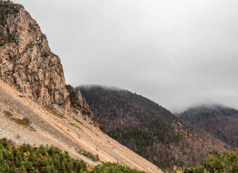
Le Buttereau Trail
Thirty minutes later, I arrived at Highland National Park and explored Le Buttereau Trail. The autumn season allows beautiful scenery of trees and plant life. This trail is worth exploring to get a beautiful view of the coastline.

View of coastline from Le Buttereau Trail
After exploring the trail, I took a rest at Auberge Doucet Inn. The clerk was very nice and allowed me to borrow her hiking stick. After learning the beauty of Cabot Trail, I extended my stay from 2 days to 3 as I felt I needed more time to explore the trails.

The room William stayed in at Auberge Doucet Inn
![]()
Park Info
Cape Breton Highlands National Park is known for its spectacular highlands and ocean scenery. Steep cliffs and deep river canyons carve into a forested plateau bordering the Atlantic Ocean. One third of the Cabot Trail, a world-famous scenic highway, runs through the national park along the coasts and over the highlands.
The cool, maritime climate and rugged landscape permit a unique blend of Acadian, Boreal and Taiga habitats, including old-growth forests of international importance.
Cape Breton Highlands National Park
Ingonish Beach, NS
Canada
B0C 1L0
 http://www.pc.gc.ca/eng/pn-np/ns/cbreton/index.aspx
 902-224-2306
 cbhnp.info@pc.gc.ca
 www.facebook.com/CBHNP
 www.twitter.com/ParksCanada_NS
Le Buttereau Trail
The self-guiding trail explores mixed Acadian forest, old fields and foundation ruins on a “buttereau” (small hill) overlooking the Chéticamp River and Gulf of St. Lawrence. Wildflowers, trees and shrubs have invaded these pastures that were once tilled by the Acadian pioneers, making an ideal spot for birds and small mammals. Plaques commemorate former Acadian homesteads.
Length: 1.6 km (1 mi) loop
Elevation: 10 – 55 m (35 – 180 ft)
Time: 30 – 45 minutes
Significant Features:Acadian history, ocean view Interpretive loop. Short climbs. Suitable for most skill levels.
Trailhead: On the Cabot Trail across from the Grande Falaise picnic area
GPS Co-ordinates for Trailhead (in decimal degrees): Lat: 46.676389 Long: -60.957946

Le Buttereau Map
Driving Directions

Trail info courtesy of Parks Canada
Driving Directions
Trailhead: On the Cabot Trail across from the Grande Falaise picnic area